Valuable Insights Gained from ISPRS Geospatial Week September 2-7, 2023, in Cairo, Egypt –
A post-conference report by Chima Iheaturu
Introduction
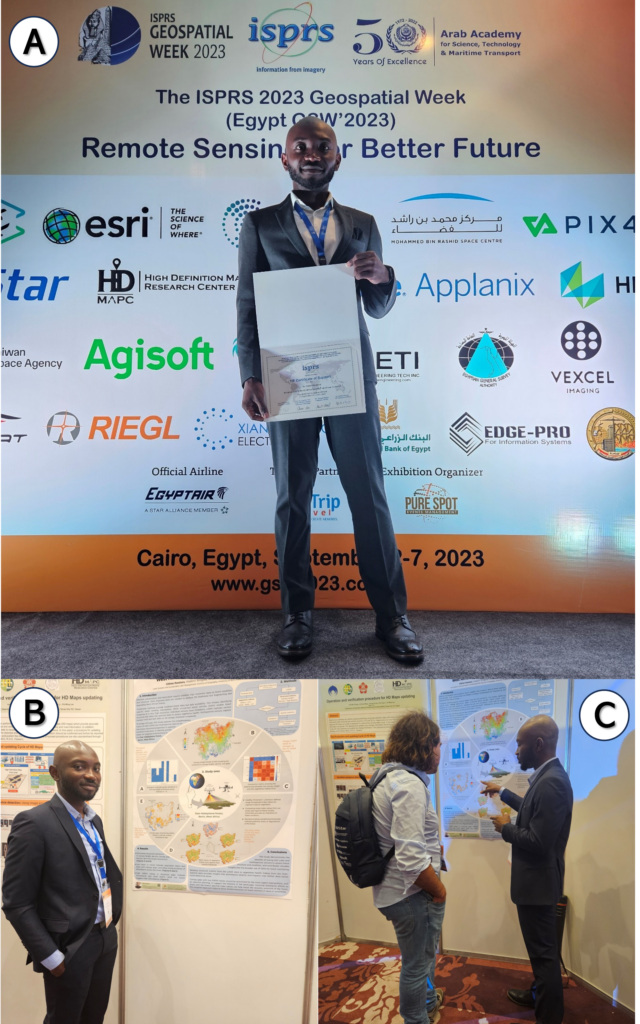
This report summarizes my participation in the International Society for Photogrammetry and Remote Sensing’s (ISPRS) Geospatial Week conference held from September 2-7, 2023, in Cairo, Egypt. As a biannual gathering of researchers across geospatial sciences and remote sensing technologies, this event provided an invaluable opportunity to share my own work and learn from top experts in my field. The theme “Remote Sensing for a Better Future” focused on technical innovations to address global sustainability challenges, directly aligning with my doctoral research on understanding forest dynamics.
Conference Overview
Spanning 6 days, this comprehensive event convened an impressive gathering of over 600 participants representing several countries and diverse sectors, including academia, government, NGOs, and industry. The intensive program comprised keynote plenaries, 35 specialized workshops, technical sessions, exhibitions, and ample networking opportunities. Workshops covered cutting-edge topics from AI in remote sensing to UAV mapping, allowing participants to engage deeply on issues related to their work.
My Presentation
I was honoured to contribute to this world-class program by presenting a poster detailing my PhD research on novel frameworks for forest ecosystem assessment. My poster introduced a methodology for fusing data from multiple sensors on UAV platforms to better understand tropical forest structure and conditions holistically. By synergistically combining 3D structural data from LiDAR with spectral vegetation indices from multispectral imagery, I showed how we can improve degradation mapping in forests. Conference interactions provided helpful feedback on relating additional metrics and validating my approach in other geographic areas. Communicating my work effectively in this global forum represented a major opportunity to build experience and strengthen my research.
Keynote Sessions
The conference featured several distinguished keynote speakers who highlighted applications of emerging technologies like big data and machine learning to tackle global development challenges.
Sohail Elabd from Esri, United States of America, discussed using AI and large datasets to enable more efficient and responsive governance. Other keynotes covered digital twin models for urban planning and satellite-based hyperspectral crop monitoring. This diverse blend of cutting-edge perspectives firmly established the conference as a premier forum for advancing geospatial research.
The talk by Dr. Mohamed Mostafa of Trimble, Canada, stood out as particularly relevant to my work. He demonstrated how combining big data analytics with machine learning can transform the geospatial industry. For example, deep learning algorithms can automate feature extraction from satellite imagery. Dr. Mostafa reinforced that emerging technologies like AI and remote sensing can drive breakthrough innovations when combined thoughtfully. I am eager to incorporate some of these leading-edge concepts, like predictive modelling and automated feature extraction, into my own research.
Parallel Sessions
With 35 simultaneous workshops occurring throughout the conference, choosing which sessions to attend proved challenging. I primarily focused on workshops closely aligned with my work in remote sensing, UAV platforms, and forest monitoring. Sessions on point cloud semantics and crowdsourced mapping were particularly valuable. In the point cloud semantics workshop, I learned new machine-learning and deep-learning techniques for the automated classification of 3D structural data that I aim to apply to degradation mapping in my tropical forest models. The crowdsourced mapping workshop also highlighted some innovative citizen science applications for forest monitoring that could provide complementary ground data to validate my UAV assessments. I look forward to maintaining connections with these groups.
Networking and Collaborations
A major highlight was connecting with fellow researchers who can help strengthen and expand my work. I initiated collaborations with scientists from Finland, Germany, Japan, South Africa, and Brazil to validate and compare my forest assessment framework in their regional contexts, which could significantly improve the methodology. I also spoke with representatives from the Digital Earth Africa initiative about accessing satellite data services to extend my approach across broader scales. These conversations demonstrated the exciting potential to grow my PhD research through new partnerships.
Personal Reflections
On a personal level, attending this conference expanded my academic network exponentially. I connected with fellow graduate students from around the globe to exchange experiences and career advice. The event also empowered me to effectively share my own work with leaders in the field. I gained exposure to a tremendous diversity of remote sensing techniques that have opened new perspectives on ways to enhance my research. My skills in communicating my science through visual, written, and oral formats grew tremendously as well. This conference underscored for me the value of actively engaging with the international community to accelerate knowledge exchange and growth.
Challenges and Questions
With so many parallel sessions, I often had to make difficult choices between simultaneously scheduled workshops. While this diversity of topics was valuable, it resulted in missed networking opportunities within certain communities. I wonder if reorganizing workshops into broader themes could improve cross-disciplinary knowledge sharing. I also noted uneven geographic representation, which points to a need to continue improving accessibility and diversity through travel grants and other means.
Future Directions
Moving forward from this conference experience, I aim to actively incorporate several of the cutting-edge techniques I learned about into my work. For example, I plan to employ point cloud semantic segmentation and structured data fusion methods to enhance degradation mapping in my 3D tropical forest models. My strengthened global network also opens doors for fruitful research collaborations that can significantly advance my PhD progress and future career. This conference demonstrated how proactively engaging with the international community provides immense resources to improve our research and scale its impact.
Conclusion
In summary, participating in the ISPRS Geospatial Week 2023 provided me with substantial professional enrichment, both from presenting my own work and learning from top minds in the field. I expanded my academic connections, gained exposure to emerging geospatial technologies, and received valuable feedback to strengthen my research. This empowering experience equipped me with new capabilities and perspectives to accelerate my PhD work on remote sensing innovations for sustainability. I am deeply grateful to ISPRS for facilitating this conference and connecting me with a global community to collaborate toward positive change.
Acknowledgements
I sincerely thank the Faculty of Science at the University of Bern for the “Support for Young Researchers” travel grant, which facilitated my attendance at this conference. I also extend my deepest gratitude to the ISPRS Foundation for selecting me as a recipient of their distinguished travel award. This recognition and support empowered me to actively participate in this global forum and accelerate my research progress. Finally, I thank the conference organizers for assembling such an impactful event that brought together brilliant minds to inspire technological innovation for the betterment of our world.