A remote sensing-based inventorying of West-Africa tropical forest patches: a basis for enhancing their conservation and sustainable use
Vladimir R. Wingate, Felicia O. Akinyemi, Chima J. Iheaturu, Chinwe Ifejika Speranza
Abstract
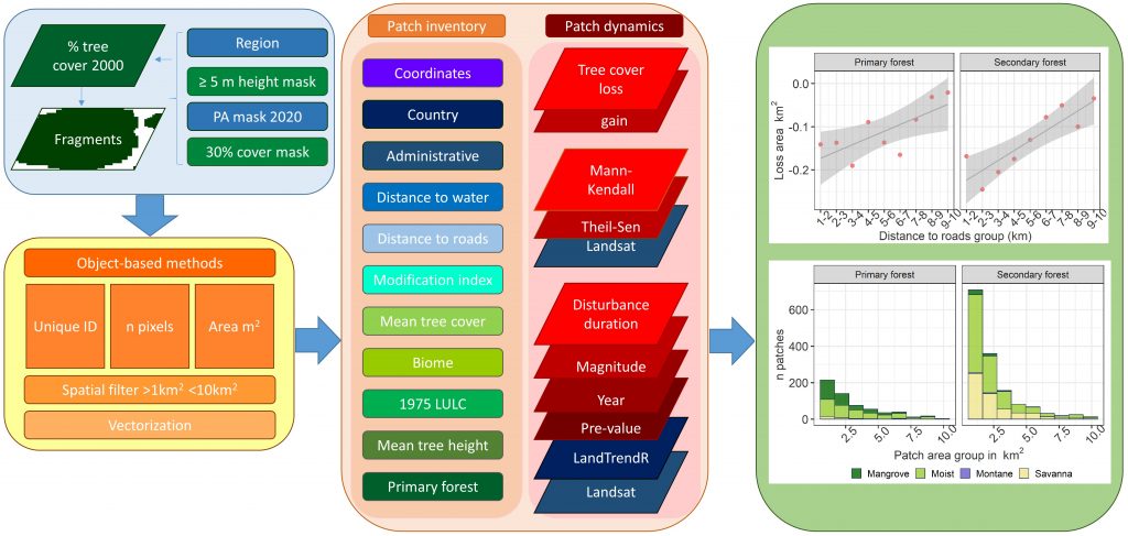
The rate of tropical forest fragmentation is increasing globally, and forest fragmentation and loss are particularly high in arable landscapes where fragments are smaller, reflecting their easier access. As such, there is an urgent need to map and monitor the dynamics of remaining smaller tropical forest patches/fragments and identify their multiple benefits and values. Recognising their existence is expected to help ensure their continued provision of social-ecological functions while facilitating their conservation and sustainable use. The main objective of this study is therefore to inventory and characterise the current extent of forest patches in Nigeria, by combining multi-source remote sensing products, time-series analyses, and ancillary datasets. We collated and analysed descriptive and dynamics metrics derived from various sources. We provided estimates of fragment size, age, biophysical conditions, and relation to social-ecological variables, which together provided insights into their dynamics over four decades. We mapped forest patches outside protected areas with a tree cover ≥ 30%, a tree height of ≥ 5 m, an area ≥ 1 km2 and ≤ 10 km2. Appended to each patch are descriptive and dynamics attributes. We find tree cover loss is widespread. The more numerous smaller fragments cumulatively lose a greater forested area, while the number of fragments increased slightly (2000-2020). Widespread greening occurs in larger fragments, the trend is pronounced for secondary forests (which predominate). Patch size is related to human disturbance metrics, e.g., distance to roads, larger patches being more distant. Finally, most patches were mapped as secondary and natural land covers (i.e., mangrove forests), in 1975. Conversely, few were mapped as human land-uses (i.e., agriculture), suggesting that forest patches rarely emerge from arable or settled land, but rather, are remnants of previously forested landscapes. Thus, this inventory forms the basis for understanding forest patch change and prioritising them for conservation, and sustainable use.
Keywords
Remote sensing, forest fragmentation, forest patches, forest change, forest inventory
Forest fragment disturbance archetypes of West-Africa
Vladimir R. Wingate, Felicia O. Akinyemi, Chinwe Ifejika Speranza
Abstract
West-Africa forest fragments are home to a wealth of biodiversity and provide crucial ecosystem functions and services with implications from local to global scales while sustaining the livelihoods and a vast number of people.
However, fragments lying outside of protected areas have no official conservation status, although they sometimes may be managed as sacred forests which limits their use and access. This situation, together with a growing demand for land and timber products, such as charcoal, has caused a great deal of forest conversions and accentuated fragmentation in recent decades.
Hence, this study is driven by the urgent need to provide land managers, researchers, and decision-makers with spatially explicit information on hotspots of forest fragment change, and so address conservation needs. Furthermore, information describing anthropogenic pressures is expected to facilitate the prioritisation of fragments for in-depth, social-ecological field investigation and conservation.
We base our study on metrics of forest change and disturbance, compiled in a recent inventory of West-African forest fragments, which aimed at characterising their spatial and temporal dynamics. Specifically, this inventory provides metrics describing forest change, such as forest loss and gain, and proximity to anthropogenic disturbance indicators, including distance to settlements and roads, as well as a wealth of ancillary indicators, ranging from biomass change to ecoregion and past land-use, thus providing the foundation for valuing the multiple uses and functions of forest patches.
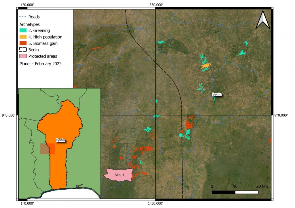
In this study, we leverage these change and disturbance metrics to develop a map of 6 forest fragment archetypes of anthropogenic disturbances, based on similarities between metrics. We use an iterative approach to process a k-means clustering algorithm that quantifies metric importance. The forest fragment archetypes enabled patterns of changes, disturbances, and anthropogenic pressures to be described throughout four West-African countries. These results facilitated the selection of representative field sites, in terms of disturbance characteristics, for in-depth social-ecological field investigations. Furthermore, they highlighted the complementary benefits of applying both concepts, namely, forest fragment inventorying and their archetyping, to inform the implementation of conservation strategies. Finally, they are expected to form the basis for informing measures to reduce human pressures and prioritising them for conservation initiatives.
Keywords
Forest fragmentation, forest patches, forest patch archetypes, forest inventory, clustering